2010년 米 국방부
아시아 지역의 영토분쟁 지역으로 카슈미르, 남사군도, 쿠릴열도, 오키나와 주변 무인 군도 등을 꼽았습니다.
하지만 한일간 논쟁이 돼 온 독도 영유권 문제는 전혀 언급하지 않았는데, 한국이 독도에 대한 실효적 지배를 하고 있다는 점을 간접적으로 인정한 것일 수도 있어 주목됩니다.


SECRET:Agreement Respecting The Disposition of Former Japanese Territories
The Allied and Associated Powers party to the treaty of peace concluded with
Japan on,1950,dispose of the territories renounced by Japan in that Treaty in the
following manner :
Article 1
The Allied and Associated Powers agree that the following territories shall be
returned in fulls over eignty to China:The island of Taiwan (Formosa)and
adjacent minor islands,including Agincourt (Hoka Sho),Crag(Menka Sho),
Pinnacle(Kahei Sho),Sanasana(Kasho To),Botel Tabago(Koto Sho),Little Botel
Tabago(Shokoto Sho),Vele Reti Rocks (Shichisei seki),and Lambay(Ryukyu Sho);
together with the Pescadores Islands(Hoko Shoto);and all other isl ands to whi ch
Japan had acquired title within a line beginning at a point in 26 °N.latitude,121 °E.
longitude,and proceeding and east to 122 °30 ′E.longitude;
Thence due south to 21 °30 ′ N.latitude;
thence due west through the Bashi Channel to 119 °E.longitude;
thence due north to a point in 24 °N.latitude;
thence northeasterly to the point of beginning.
This line in indicated on the map attached to the present Agreement.
Article 2
The Allied and Associated Powers agree that the island of Sakhalin(Karafuto)south
of 50 °N.latitude,and adjacent islands,including Totamoshiri(Ka i b a T o ,o r
Moneron),and Robbon Island(Tyuleniy Ostrov,or Kaihyo To)shall be transferred
to the Union of Soviet Socialist Republics in full sovereignty.
Article 3
The Allied and Associated Powers agree that there shall be transferred in full
sovereignty to the Republic of Korea all rights and titles to the Korean Mainland
Territory and all offshore Korean islands,including Quelpart(Sai shu To),the Nan
how group (San To,or Komun Do)which forms port Hamilton(Tonaikai),Dagelet
Island(Utsuryo To,or Matsu Shima),Liancourt Rocks(Takeshima),and all of her
islands and islets to which Japan had acquired title lying outside … and to the
meridian 124 °15 ′ E.longitude,north of the parallel 33 °N.lati tude,and west of a
line from the seaward terminus of the boundary approximately three nautical miles
from the mouth of the Tumen River to a point in 37 °30 ′N. latitude,132 °40 ′E. longitude.
This line is indicated on the map attached to the present Agreement.
Article 4
The Allied and Associated Powers undertake to support an application by the
United States for the placing of the Bonin Islands (Ogasawara Gunto)including
Rosario Island(Nishino Shima),the Volcano Islands(Kazan Retto),Parece
Vel n(Dougl as R eef ),a nd Mar cus I sl and(Mi nami t or i Shi ma)u nder Trusteeship in
accordance with Articles 77,79 and83 of the Charter of the Uni ted Nations,the
trusteeship agreement to designate the islands as a strategic area and to provide
that the United States shall be the administering authority.
Article 5
The Allied and Associated Powers undertake to support and appli cation of the
United States for the placing of the Ryukyu Islands south of 29 °N.latitude under
trusteeship in accordance with Article 77,79 and 85 of the Charter of the United
Nations,the trusteeship agreement to provide that the United States is to be
administering authority.
Done at the city of ------------in the English language,this -------day of
------,1950.
---------------------------------------------------------------------------
연합국측은 제2차 세계대전의 강화조약 체결 준비를 1949년부터 본격적으로 시작하였다.이 때 연합국측은 극비리에 『연합국의 구일본영토 처리에 관한 합의서 』(Agreement Respecting the Disposition of Former Japanese Territories)를 합의하여 작성하였다.
이 합의서의 제3항은 다음과 같이 제주도,거문도,울릉도,독도(Liancourt Rocks,Takeshima)를 완전히 대한민국의 주권에 반환한다고 다음과 같이 규정하였다.
『제3항:연합국은 일본이 과거에 영유권을 획득했던 한국본토와 모든 주변의 섬들(제주도
-Quelpart,거문도-Hamilton,울릉도-Dagelet island,독도-Liancourt Rocks,Takeshima)과 그 밖의 섬들을 일본에서 제외하여 대한민국(the Republ ic of Korea)의 주권에 완전히 이양할 것을 합의한다.』
연합국이 독도를 한국영토로 판정하여 반환시켰음을 극명하게 보여 주는 귀중한 자료이다.
연합국은 위의 합의서에도 문제를 명료하게 해두기 위해 지도를 작성하여 첨부하였다.
연합국은 대일강화조약(샌프란시스코 조약)을 준비함에 있어서 1949년 합의 작성된 극비의
"합의서"에서 독도(Liancourt Rocks)를 한국영토로 결정하고 지도까지 그려 재확인한 것이다.
.jpg)
기밀 보안 정보
11/14/52
친애하는 Al :
내가 1952년 10월 3일, "한국인은 독도에서"뿐만 아니라 부산의 각서 1952년 10월 15일, 권리로서, 권리의 도쿄 특파 모두 읽었 No.659
라이브 폭파 지역 "에 동봉된 같은 분쟁 지역 (독도 섬)의"를 사용하여
대사 머피 1952년 10월 16일의 편지.
그 부서의 입장이 바위와 일본에 속한 그래서 워싱턴의 한국 대사 촬영 정보를 가지고있다가 나타납니다. 대한민국의 견해의 일본어 평화 조약 초안 작성 과정에서, 그 결과이 중 한국 대사가 국무부 7 월 19 일 1951 제 2 조 () 초안은 조약의 개정에 너무 letetr에 요청 유혹했다 독도의 섬 (독도)와 Parangdo뿐만 아니라 Quelpart, 포트 해밀턴과 Dagelet 넘는 일본의 권리, 소유권을 포기하고 한국의 독립을 인정하는 미덕에 의해 주장을 그 섬 사이를 포함합니다. 한국 대사 장관은 자신의 답장 편지 8월 10일 일자, 1951 년 그것 독도에 자신의 정보를 독도에 따라 적용 이후 미국에서 제안된 개정안로 취급되어 적이 없었 명시된 바와 같이 동의 한국의 일환으로, 그들은 오키 제도 출장소 일본 시마네현의 관할하에 1905 년부터 있었다 그리고 그것은 그들이 전에는 결코 한국이 주장왔다가 표시되지 않았다. 마찬가지로 그 결과 제 2 조 () 조약을 평화의 일본과 독도에 대한 언급이있습니다
"일본, 한국의 독립을 인정하는 모든 권리, 소유권, 그리고 주장을 한국, Quelpart, 포트 해밀턴과 Dagelet의 섬을 포함하여 포기."
의 E. 앨런 Lightner, 에스콰이어
충전 디, 인공 지능 affaires
미국 대사관, 부산, 한국.
코드 FE : 없음 : RMHerdon - EB
1952년 11월 5일
주사해 Amembassy, 도쿄
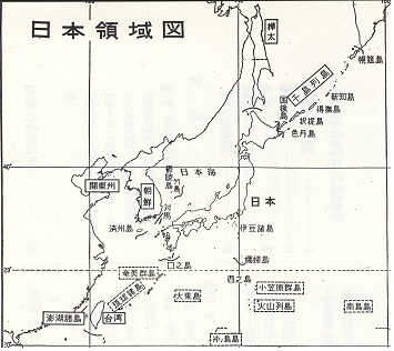
<자료 7> 일본영역도(『대일강화조약』(마이니치신문사편, 1952)) : 대일강화조약 체결 직후 일본 정부도 당시 독도가 일본의 관할구역에서 제외된 사실을 확인하고 있다.
.jpg)
2차 세계대전 전후처리를 위해 연합국과 패전국 일본이 1951년 9월 8일에 독도를 한국영토로 규정한 영국정부의 자료가 발굴됐다.


▲ 독도(일본명 죽도·竹島)를 조선, 대만 등과 함께 외국으로 규정한 1946년 8월
일본 대장성 고시 654호.
2006 독일 월드컵(오프닝)사진
일본
한국
연합국최고사령부의 韓日영토 규정

연합국최고사령부 제2차 세계대전 후 일본이 영토를 규정한 지도.
(일본과 한국의 행정 관할 구역을 구분한 지도이다)