태평양전쟁 후, 일본의 영토를 결정했다
샌프란시스코 조약
일본과의 평화 조약(샌프란시스코 조약)
제2조(a)
일본은, 조선의 독립을 승인하고,
“제주도(Quelpart)”, “거문도(Port Hamilton)”및
“울능도(Dagelet)”를 포함한 조선에 대한다
모든 권리, 권원 및 청구권을 방폐한다.
┐(′-`)┌야레야레상의 문장을 기억해 주세요.
┐(′-`)┌야레야레, SF조약의 초기의 초안.
U.S. Draft made on November 2, 1949
요즘은 타케시마가 조선으로서 다루어지고 있습니다.
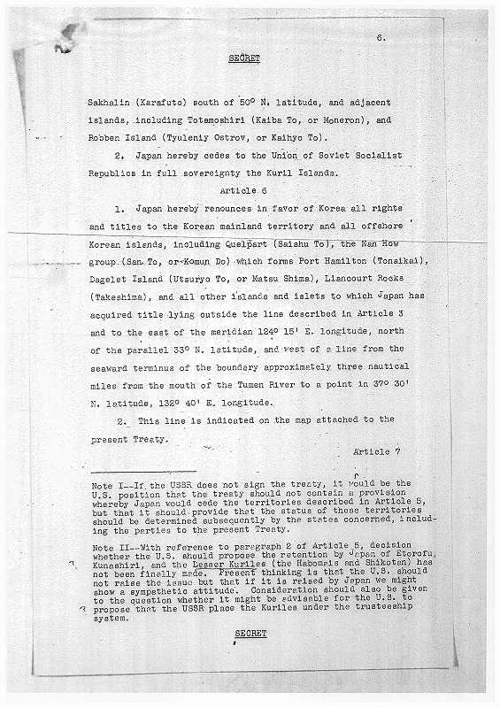
Article 4
1. Japan hereby renounces in favor of the Korea all rights and titles to the Korean mainland territory and all offshore Korean islands, including Quelpart (Saishu To), the Nan How group (San To, or Komun Do) which forms Port Hamilton (Tonaikai), Dagelet Island (Utsuryo To, or Matsu Shima), Liancourt Rocks (Takeshima), and all other islands and islets to which Japan has acquired title lying outside the line described in Article 3 and to the east of the meridian 124о15" E. longitude, north of the parallel 33оN. latitude, and west of a line from the seaward terminus of the boundary approximately three nautical miles from the mouth of the Tumen River to a point in 37о30" N. latitude, 132о40" E. longitude.
2. This line is indicated on the map attached to the present Treaty.
기사 4
1. 일본 이것에 의해서 방폐합니다로호의를 나타냅니다, 그 한국 문제 없습니다 및 타이틀에의 그 한국인 본토 영토 및 거기에 일본이 라인의 밖에서 타이틀 가로 놓이는 장소를 획득한 Quelpart ( Saishu To ), 포토·해밀튼( Tonaikai )을 만드는 낭 방법 그룹(산 To, 혹은 Komun드)을 포함한 완전히 바다로 향하는 한국의 섬, Dagelet섬( Utsuryo To, 혹은 Matsu Shima ),Liancourt바위( Takeshima ),및 다른 모든 섬, 및 작은 섬이 기사 3으로, 및 자오선의 124о15의 동쪽으로 말했던'E.경도, 평행 하고 있는 33оN.위도의 북쪽, 및 바운다리 약 3 해리의 바다쪽목적으로부터의 라인의 서쪽에서 37о30의 1포인트에의 Tumen강하구와.위도, 132о40'E.경도.
2. 이 라인은, 현재의 조약에 설치된 지도에서 나타납니다.
┐(′-`)┌야레야레, 그 후
U.S. Draft made on December 29, 1949
에서 타케시마가 일본령이 됩니다.
.jpg)
.jpg)
일본의 영토로서 기재된 것영어
Territorial Clauses
Article 3
1.The Territory of Japan shall comprise the
four principal Japanese islands of Honshu, Kyushu,
Shikoku and Hokkaido and all adjacent minor islands,
including the islands of the Inland sea(seto Naikai);
Tsushima,Takeshima (Liancourt Rocks), Oki retto,
Sado, Okujiri, Rebun, Riishiri and all other islands
in the Japan Sea (Nippon Kai) within a line connecting
the farther shores of Tsushima, Takeshima and Rebun;
the Goto archipelago, the Ryukyu Islands north of 29о
N. Latitude, and all other islanls of the East China
Sea east of longtude 127о east of Greenwich and
north of 29оN. Latitude; the Izu Islands southward
to end including Sofu Gan (lot"s Wife) and all other
islands of the Philippine Sea nearer to the four
principal islands than the islands named; and the
Habomai group and Shikotan lying to the east and south
of a line extending from a point in 43о35" N.Lati_
tude, 145о35" E. logitude to a point in 44оN.
latitude, 146о30" E. longitude, and to the south
of a line drawn due east on the parsllel in 44о N. Lati_
tude. All of the islands identified above, with a
three-mile belt of territorial waters, shall belong to
Japan.
일본이 방폐하는 영토로서 기재된 것영어
Article 6
Japan hereby renounces in favor Korea all
rights and titles to the Korean mainland territory
and all offshore Korean islands, including Quelpart
(Saishu To), the Nan How group (San To, or Komun
Do) which forms Port Hamilton (Tonaikai), Dagelet
Island (Utsuryo To, or Matsu Shima), and all other
offshore Korean islands and islets to which Japan
had acquired title.
일본의 영토로서 기재된 것기계 번역
기사 3
1.일본의 영토는, 내해( seto Naikai )의 섬을 포함한 혼슈, 큐슈, 시코쿠, 및 홋카이도의 4개의 주된 일본의 섬 및 전혀 근처의 중요하지 않은 섬을 포함 하겠지요;Tsushima,Takeshima ( Liancourt Rocks ),바다 retto, Sado, Okujiri, Rebun, Tsushima, Takeshima, 및 Rebun의 것보다 먼 기슭을 묶는 라인내
-생략-
위의 모든 섬은, 일본에 속하겠지요.
일본이 방폐하는 영토로서 기재된 것기계 번역
기사 6
일본은, 거기에 타이틀을 획득한Quelpart ( Saishu To ), 포토·해밀튼( Tonaikai )을 만드는 Nan How 그룹(산 To, 혹은 Komun드), Dagelet섬( Utsuryo To, 혹은 Matsu Shima ),및 다른 모든 바다로 향해 한국의 섬, 및 작은 섬을 포함하고, 문제 없는 호의 한국, 및 한국의 본토 영토, 및 완전히 바다로 향하는 한국의 섬에의 타이틀로 이것에 의해서 방폐합니다.
샌프란시스코 조약
일본과의 평화 조약(샌프란시스코 조약)
제2조(a)
일본은, 조선의 독립을 승인하고,
“제주도(Quelpart)”, “거문도(Port Hamilton)”및
“울능도(Dagelet)”를 포함한 조선에 대한다
모든 권리, 권원 및 청구권을 방폐한다.